We use cookies to ensure our site functions properly and to store limited information about your usage. You may give or withdraw consent at any time. To find out more, read our privacy policy and cookie policy.
Manage Cookies
A cookie is information stored on your computer by a website you visit. Cookies often store your settings for a website, such as your preferred language or location. This allows the site to present you with information customized to fit your needs. As per the GDPR law, companies need to get your explicit approval to collect your data. Some of these cookies are ‘strictly necessary’ to provide the basic functions of the website and can not be turned off, while others if present, have the option of being turned off. Learn more about our Privacy and Cookie policies. These can be managed also from our cookie policy page.
Strictly necessary cookies(always on):
Necessary for enabling core functionality. The website cannot function properly without these cookies. This cannot be turned off. e.g. Sign in, Language
Analytics cookies:
Analytical cookies help us to analyse user behaviour, mainly to see if the users are able to find and act on things that they are looking for. They allow us to recognise and count the number of visitors and to see how visitors move around our website when they are using it. Tools used: Google Analytics
Share Cornell Rouge National Urban Park Gateway Study on FacebookShare Cornell Rouge National Urban Park Gateway Study on X (formerly Twitter)Share Cornell Rouge National Urban Park Gateway Study on LinkedinEmail Cornell Rouge National Urban Park Gateway Study link
Consultation has concluded
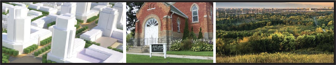
The Cornell Rouge National Urban Park Gateway is envisioned to be an exciting public space connecting Cornell Centre to the Rouge National Urban Park (RNUP). It will serve both Markham residents and visitors to the RNUP by providing urban amenities in Cornell Centre and additional amenities and services for those seeking to explore the natural, cultural and agricultural landscapes of the RNUP.
There are several objectives for the Gateway:
Provide for integration and an appropriate transition between urban development and the Park.
Create an animated and vibrant streetscape along Highway 7 with activities and land uses that are complementary and supportive of the community and Park visitors.
Support alternative transportation options including pedestrian, cycling and transit connections between Cornell Centre and Rouge National Urban Park.
Respect and protect the residential community of Locust Hill.
Purpose of the Study
The purpose of the Cornell RNUP Gateway Study is to identify streetscape and design solutions to create an exciting and memorable public space. The study will provide recommendations: to improve landscaping and walking/biking conditions along Highway 7 and Reesor Road; to provide an animated and active public realm; and to provide for a clear interface and transition between urban development and the RNUP.
Location and Context
The Rouge National Urban Park is the first and only National Urban Park in Canada and is the largest urban park in North America. The Park comprises 79 square kilometres in Toronto, Markham, Pickering and Uxbridge. The Park comprises over 16% of the total land area in Markham. The Government of Canada has tabled the Rouge National Urban Park Management Plan and are proceeding with the implementation of programming and park infrastructure throughout the Park including the construction of visitor centres and trails.
Cornell Centre is located at the western end of the Gateway and is planned to become the largest urban centre located directly next to the Park. The development of this community as a high density, mixed-use centre can help support the Park’s objectives and create a unique visitor experience through high quality urban design, an animated public realm and by providing services that cater to both local residents and Park visitors. A review of the Cornell Centre Secondary Plan is currently underway.
The hamlet of Locust Hill is located at the eastern end of the Gateway. Locust Hill is a small residential hamlet located on Highway 7 which traces its roots to the historic Locust Hill railway station. The Markham Official Plan seeks to protect and maintain the historic and rural residential character of these settlements while addressing improved streetscape conditions.
What is being proposed?
Pedestrian and cycling facilities along Highway 7 and Reesor Road to connect Cornell Centre and Rouge National Urban Park
Opportunities to improve the pedestrian environment in the Gateway Area such as landscaping, planters, seating, enhanced urban design, architectural design and interactive public art.
Parks Canada is also planning to construct a welcome area, trail systems and other visitor facilities within and adjacent to the Gateway Area.
For more detailed information, access the presentation and display boards for the April 2019 Public Open House which can be found in the 'Documents Library' tab on the right side of the screen.
Study Update
January 2020 - The Cornell Rouge National Urban Park Gateway Study was endorsed by Markham Council in January 2020. The final study can be found under the Documents Library Tab. City staff are working with stakeholders to implement the Gateway Study. For more information, please contact staff at 905.477.7000 extension 7925.
Cornell Rouge National Urban Park Gateway Study has finished this stage
A three day workshop was held in November 2015 with Council, public agencies, stakeholders and members of the public to generate ideas and a vision for the Cornell Rouge National Urban Park Gateway.
Initiation of Gateway Study
Cornell Rouge National Urban Park Gateway Study has finished this stage
The Gateway Study was initiated in May 2018 to review the ideas that arose from the 2015 Charrette and Design Workshop and to prepare a Streetscape Concept and Vision Plan for the study area.
Background Analysis
Cornell Rouge National Urban Park Gateway Study has finished this stage
A background review and strengths, weaknesses, opportunities and threats (SWOT) analysis was completed.
Draft Streetscape Design Concepts
Cornell Rouge National Urban Park Gateway Study has finished this stage
Development of draft concepts for streetscape and design improvements to the study area will be developed.
Final Streetscape Design Concepts and Implementation Framework
Cornell Rouge National Urban Park Gateway Study is currently at this stage
Based on feedback from stakeholders, streetscape design concepts will be revised and finalized. An implementation framework will be developed to outline steps to achieve the Gateway vision.