

FAQs (as of Oct 24, 2025)
Is road safety an issue on this corridor?
The subject portion of Main Street Markham has vehicle speeds that are well in excess of the posted speed limit (10-20 km/h over). Also, the City has received ongoing concerns from the community about safety and livability along the corridor. Collisions in particular are very high in the area, with a frequency of approximately eight (8) collisions per year. For a 1.2km stretch of road this is concerning and requires appropriate measures to be taken to address the issue.
This study is intended to improve safety for all road users through the development and implementation of traffic calming measures.
What is the benefit of implementing traffic calming measures?
Safety is the key benefit from introducing traffic calming. Measures implemented encourage slower and more careful driving, leading to fewer and less severe crashes. Neighbourhood residents feel more comfortable, particularly seniors and families with young children, walking or cycling in the area given the reduction in speeding drivers.
Neighbourhood attractiveness can also improve with residents feeling safer to walk or cycle and cars emitting less pollutants due to slower driving (i.e., better air quality), as well as reducing noise pollution from vehicles.
What are some examples of traffic calming measures being considered?
Examples of traffic calming measures include lane narrowing, road diets (reduction in lanes), on-street parking, controlled pedestrian crossings, etc.
How will safety improvements be determined?
In addition to conducting a safety review of the corridor, feedback from public consultation will play a key part in the selection of proposed traffic calming measures. Comments received from the PICs and from input provided on this webpage will be considered. The traffic calming measures will be to the City’s standards and selection based on local concerns, feasibility, costs, and potential benefits.
Will pedestrian crossing opportunities be reviewed as part of the study?
Yes. Pedestrian and cyclist volumes along the corridor will be reviewed to identify new pedestrian crossing opportunities. Generally, road segments adjacent to schools, shopping malls, parking lots, and major public transport hubs such as GO stations will have higher levels of pedestrian activities. For example, the surroundings of the Markham GO Station will have a moderate to high level of pedestrian crossings.
Strategies in accordance with the Accessibility for Ontarians with Disabilities Act (AODA) to support walking and cycling will be considered, especially at pedestrian crossovers.
When will these improvements be implemented?
Detailed design of the corridor is anticipated to be completed by summer 2024. Implementation of proposed improvements are to begin and end in 2025, subject to budget approvals.
What is happening to the revitalization of Main Street Markham?
This Traffic Calming project is responding to and addressing current traffic safety concerns on this stretch of Main Street Markham. The objective is to recommend interim and short-term solutions to improve safety for all users and make Main Street Markham a more inviting environment overall. Importantly, data, ideas, options and proposed improvements from this project will help inform the development of the permanent design of this road corridor.
Will reducing the number of lanes create more traffic congestion?
A common misconception is that road diets create more traffic congestion. If applied correctly, road diets can maintain a roadway’s effective capacity. For example, a corridor like Main Street Markham has numerous driveways and side streets, so the majority of through traffic tends to utilize the outside travel lanes to avoid being delayed by left-turning vehicles slowing and stopping in the inside travel lanes. As a result, the four-lanes essentially behave like a three-lane road already. Therefore, if Main Street Markham is converted to a three-lane cross-section through a road diet, it is unlikely to increase congestion overall.
In addition, the City has conducted a thorough analysis comparing traffic operations under existing conditions and expected conditions post-road diet. The analysis concluded that there will be no appreciable increase (less than 30 seconds) to travel times during both morning and afternoon peak periods.
Main Street is a main artery. Why would the City reduce the number of lanes for commuters?
Main Street Markham is classified as a major collector (not arterial) road, where interrupted flow with more driveways is a typical characteristic of a collector road. Mobility safety and accommodation of pedestrians and cyclists are prioritized.
In a historical area, road operations need to be complimentary to local area needs, including residents and local businesses. Commuter traffic could consider using arterial roads as alternates, such as, 9th Line, McCowan, Donald Cousens Pkwy.
Will street parking be accommodated on Main St?
Except where signs may already be posted, parking is not prohibited through municipal by-law. Therefore, not enforceable. A parking utilization study was conducted and confirmed there are very little street parking activities.
The City may consider imposing restrictions in future, if operational issues are observed on a consistent basis. If a vehicle is parked, drivers can encroach into centre left-turn lane, provided it is safe to do so.
Nobody rides bikes on Main Street. So why do we provide bike lanes?
This project is intended as a traffic calming project first and foremost. Reduction in travel lanes is necessary to achieve slower vehicle speeds and reduced collisions. The residual pavement width presents opportunity for bike lanes, and it also addresses gap in the City’s cycling network, as identified in the Active Transportation Master Plan (ATMP).
Can you raise the gates at the railway crossing when the train stops at Markham GO?
The City has consulted with Metrolinx prior to this project, as it has been a long-standing issue. Metrolinx said the equipment used to trigger gates cannot be adjusted, in accordance with Transport Canada regulations. The City will continue to correspond with Metrolinx to explore opportunities. For more info, please contact: Vic Pacioaga, Senior Manager, Signal and Communications, Level Crossings, Vicentzo.Pacioaga@metrolinx.com, (416) 202-0129.
Why not build bike facilities on the boulevard?
There is no sufficient right-of-way to provide for boulevard facilities. To do so, it would require land appropriation, which would come at significant cost.
Why isn’t Main Street being rebuilt and revitalized as part of this project, like it was south of Bullock Drive?
This project is a quick-build pilot. It is intended as a proof-of-concept exercise and will inform future revitalization plans on Main Street Markham.
Road reconstruction and underground service upgrades and replacement is currently in design phase. Construction is anticipated to start in 2028, pending budget approvals and required permits.
Did the City consult the community before proceeding with this project?
Two Public Information Centres (PICs) were conducted. The First PIC presented safety concerns, preliminary safety study results, and potential options; solicited community feedback. The Second PIC presented more refined design options, considering feedback received at First PIC.
The City also facilitated a mail-out to approx. 1500 households prior to each PIC. Advertisements were made via mobile signs placed on Main Street and electronic billboards on City properties. Lastly, this project website was created to solicit public feedback.
What are the expected effects from the road rebalancing, once implemented?
1) Traffic delays are expected to be higher during the peak hours for the first few months. After then, it is expected that some traffic may shift to off-peak hours, or to alternative roadways. City staff will continue to monitor its changing traffic pattern.
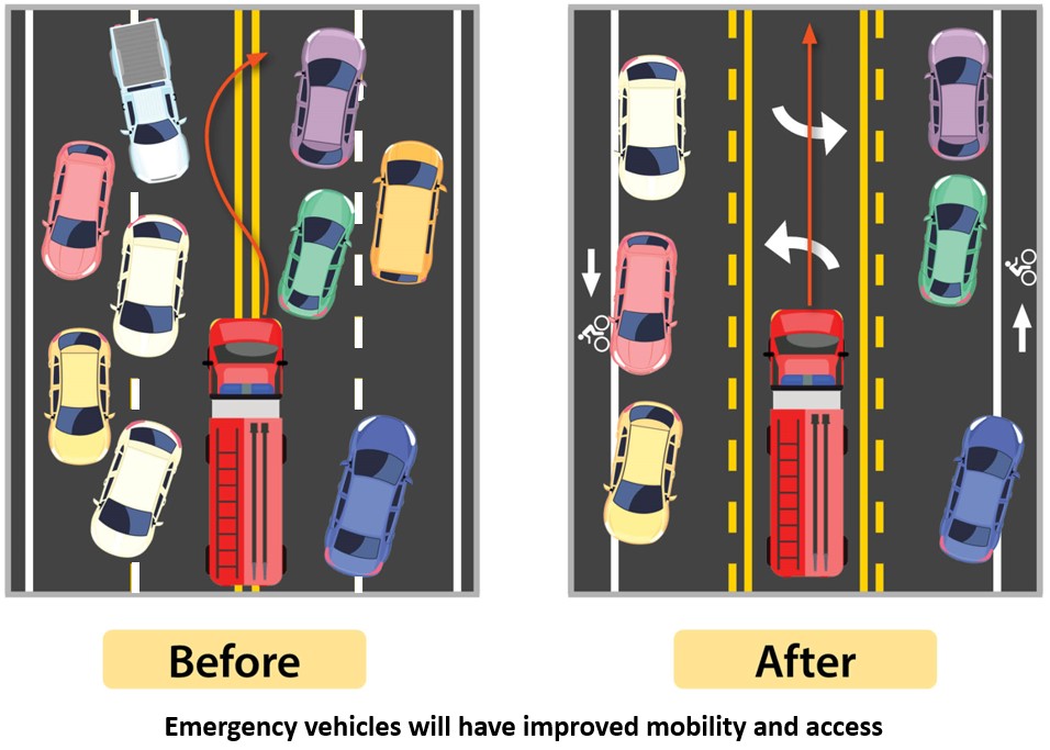
2) Improved travel time for emergency vehicles. The centre turn lane will be empty for much of the time, allowing emergency vehicles to use it. Any vehicles present within the lane can easily move to into the thru lane to allow for emergency vehicles to safely pass. See image below.
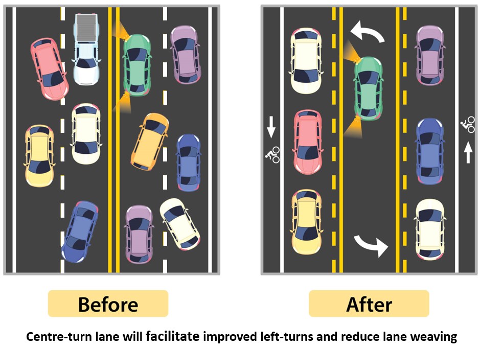
3) Improved left-turning vehicles for 7 roadways and 69 driveways, thus creating a safer road.
4) Lesser weaving/passing of vehicles along the corridor with consistent number of lanes between 16th Ave and Hwy 7, thus creating a safer road.
5) Reduced traveling speed that more closely aligns to the posted speed limit and compliments the surrounding land context.
6) Reduced number and severity of collisions.
7) Included mobility choice for people who opted to ride a bicycle.